Navigating the West Virginia 511 Website
The West Virginia 511 website provides traveler information for those living in and visiting West Virginia. It is available on your computer or mobile device. However, please be safe, and do not use any hand-held device while operating a vehicle.
Incident and construction information is available for Interstates, US routes, and state routes across West Virginia.
Traffic Conditions

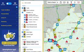
The home page features an interactive map that shows incidents, active & future planned events, reported speed, cameras, signs, weather conditions, forecasts and advisories across West Virginia.
The legend at the side of the map allows you to decide what you will see on the map. You may select different layers, including Incidents, Planned Events, Cameras, Road Conditions, Commercial and Other Information.

You can also control your view of the map by using the “ZOOM TO” menu.
Select a region and the map will automatically zoom to that area.
Use the SAVE icon to store your preferred zoom level, and click the GO TO MAP VIEW icon to quickly zoom to your saved view. Want to clear the saved view? Click the CLEAR SAVED VIEW icon marked by a trash can image.
Of course, regular map controls located at the bottom of the map, also work.
Some notable features of the map:
- By zooming in on a region with the “Traffic” option enabled, speed data will be visible on more roadways.
- All available cameras can be seen at the statewide view. There is no need to zoom in on a region to view additional cameras. However, in areas that have a lot of cameras nearby each other, multiple cameras may be represented by a single icon. Clicking on this icon will zoom the map enough to see the individual cameras in that area.
- Weather alerts and forecasts are available for every county as icons on the statewide map view. If there is a multi-county alert, the affected area will be shaded with a light red color.

You can also click the ALERTS AS TEXT icon to see a list of the current alerts and advisories that can be sorted by region and roadway or time of update.
You may also view the data from several layers as a text listing by clicking the links under the TRAVEL CONDITIONS item on the navigation. Notice that you can view all reported West Virginia Statewide conditions, or you may narrow the listing down to your specific region by selecting a region in the “Select Regions” dropdown menu.
Other Website Features
The website will automatically re-size, based on your screen size, for optimal viewing on your phone, tablet and desktop/laptop. On larger screens you can also collapse the left hand navigation to suit viewing preferences for your device.
When the screen size is small, such as a mobile phone, the navigation menu will be available by tapping on the blue bars on the top left of the screen.
Check My Route
Click the “Check my Route” button on the map and enter a starting and ending address to plan a route using Google Directions. The system will display information about all relevant map layers encountered on the trip, including incidents, active construction, active signs, and traffic cameras.
Trips for passenger vehicles will also include turn-by-turn directions, and trips for commercial vehicles will include truck parking facilities, runaway truck ramp locations, and steep grade locations. Users can modify their view by turning on or off any layers from the map legend.
Desktop computers will allow users to click on an item in the Check My Route results, and snap to that location on the map. In mobile mode, the event, camera, or sign will appear right in the Check My Route results listing.
More Resources
You can sign up for email or text travel alerts, explore commuter transit options, or click through to suggestions on how to explore the state on this website.
If you have a comment or suggestion, just use our Feedback form. Your suggestions can help us continue to improve the site and the traveler information service.